This will be an easy run, suitable for Noobs, FNG's or anyone who just needs some low-stress seat time in the mountains. I would especially like to invite all of our newest Bronco 6G members who are new to off-roading and want to get their feet wet with an easy run. But all So Cal Broncos are welcome, from OG to 6G.
RSVP REQUIRED
ABOUT THE ROUTE
MEETING TIME
GETTING TO THE TRAILHEAD
MAPS & GPS DATA
If you would like to check out the route for yourself and/or pre-load it into your GPS device or app, I've provided the routes and waypoints resources below. Note that you are free to use this map any time, so if you can't make it to this run, perhaps you might consider running it another time with a group of friends.
BE PREPARED
Please be prepared for a long day on the trail, in some remote back-country. Here are some things you should bring:
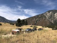
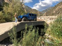
That's it! If you have any questions please ask them in the comments below. Here are a couple of pics from a run we did on this route not too long ago, in our Early Bronco, with some of our local friends. The first is from Keller Cliffs, the second one is from the Seven Pines area, the last one is from the Bear Creek bridge, in our old Jeep.


RSVP REQUIRED
If you would like to join us, please respond in this thread with your name(s) and the year and color of your Bronco as shown below. I'll add your name onto this list in the order it's posted. We'll be capping participation at 20 rigs. If you have friends with another Bronco that wants to come, let them know they will need to come to this thread and add their information themselves, rather than you adding them.
- Dusty & Steffie Sharp, '21 White 2-door Base
- Lucia and Joerg Hallbauer, Blue Bronco Badlands
- Jamie and Jose Castaneda, ‘22 White 4D WT/Hoss
- Terry Marvel, 2021 Bronco 2door badlands Cyber Orange
- Scott and Bonnie Butler, 2021 4dr. Badlands cyber orange
- Rob Potts , 2021 Lightning Blue 4-door
- Chris & Pat "Stormi" 22 4D Carbonized Gray Badlands Squatch on 37's
- Matt & Fate with Base Sasquatch Carbonized Gray beauty!
- Mike B, ‘70 Orange Halfcab
- Anthony Garcia, 22’ Big Bend 2 Door Velocity Blue
- Don & Nelson, 2021 black diamond 4 door , race red
- Tommy McNicholas, 2021 4DR Area 51 Badlands
- KAI & Ingrid, 22`wildtrak 4D Eruption green
- Jason 2022 Cyber Orange 4d Wildtrack
- Carlos Mendez, 22 4 door carbonized gray BaseSquatch
- Barry Grogan, ‘22 - 2-DR - Black Diamond - Area 51
- Kurt and Cristen Gerum, 2021 4 door fist edition cactus grey
- Frank & Kelly Aguilar, 22' Black D Sas CarbG
- Oscar espinoza 2021 bronco
- The Brothers Bogner in "Fugly"
- Rick White, 21 Badlands, Sasquatch 2 door Carbonized Gray
The route will take us from Highland up into the San Bernardino Mountains, along a route that very roughly parallels the Santa Ana River, but high along the north bench, providing some great views of the backcountry and the valleys below. Along the way we'll pass the Seven Oaks Dam (from a distance), Keller Cliffs, Manzanita Flats, Bear Creek (where we might stop for lunch or to cool our feet), Seven Pines, Clark's Ranch, Converse Flats, and ending up at the Santa Ana River where it crosses under Highway 38 up past Barton Flats. We will cover nearly 40 miles on dirt and gain almost 4,500 feet in elevation. The route uses forest service roads which can be bumpy, sometimes rutted and a little rocky, but all of it should be passable in 2 wheel drive. So ANY Bronco in good working order is suitable for this run. The only caveat being, especially for our Early Bronco friends, to make sure your cooling system is in good working order as there are some long, sustained climbs.
If you would like to check out the route for yourself, I have set up THIS GOOGLE MAP with route and waypoints. Note that you are free to use this map any time, so if you can't make it to this run, perhaps you might consider running it another time with a group of friends.
MEETING TIME
We will depart the Staging Area at 9:00 AM on August 13th. Please arrive early to allow time to air down (if desired--more on that below), socialize, or buffer time in case of traffic getting to the trailhead.
GETTING TO THE TRAILHEAD
The run will stage at the beginning of Alder Creek Road (Forest Service Road 1N16) in Highland, CA. Please be aware that the approach to Alder Creek Road has been altered significantly by recent construction of new homes and streets. Most online maps and GPS software will not be updated for the new street alignments yet. However, I have provided waypoints and GPS route in THIS MAP on Google Maps. If you aren't savvy with using GPS apps, you can simply search for the East Valley Water District in Highland, California, on your phone and have it give you directions in whichever app you're comfortable with using. Then follow these directions:
- Find your way to East Valley Water District, 31111 Greenspot Rd, Highland, CA 92346. Note that this address is being used for reference, it is not your actual destination.
- When you approach the Water District entrance, turn the opposite direction, on to a new street that has just been constructed, across Greenspot Road from the Water District. This is Mediterra Parkway. It probably does not show up on your map software yet. If you are coming through Highland as most of you will, the Water District is on the right, you will be turning left (North) onto Mediterra Parkway.
- After making the turn, you may see a bright yellow sign with an arrow that points to "Fire/Forestry Access 1N16". The road will pass a small roundabout then curve to the left, becoming Avenida Ramblas.
- Turn right at Sorrento Way. There may be another bright yellow sign pointing you in the right direction.
- Sorrento Way is very short, only a couple of hundred feet to a cul-de-sac at it's end. This is where we will meet to stage for the run. For those of you using the GPS waypoints, this is the second waypoint on the list, "Alder Creek Road NEW Start Point".
It's very important to remember that if you simply enter Alder Creek Road or 1N16 into your map app, it might send you to the wrong place. If you've done this trail before, but not recently, it's probably completely different now.
MAPS & GPS DATA
If you would like to check out the route for yourself and/or pre-load it into your GPS device or app, I've provided the routes and waypoints resources below. Note that you are free to use this map any time, so if you can't make it to this run, perhaps you might consider running it another time with a group of friends.
- The Route on Google Maps
- Route & Waypoints GPS data in KML format
- Route & Waypoints GPS data in GPX format
- Route & Waypoints on Gaia (requires membership)
For this run we will be using 146.535 VHF for communications. If you already own or will be buying a radio prior to the run, please make sure this frequency is programmed into it prior to the run.
It isn't necessary to have a radio for communications on the trail, but it will enhance your experience knowing what's going on with the group, hearing directions and points of interest from the run leader, and knowing what's going on if there's a stoppage ahead or behind you. And of course its a huge help if you are the one needing assistance. If you don't have one, you will still have a great time. But if you can get one before the run, I highly recommend it.
In So Cal Broncos we primarily use 2-Way VHF radios in the 136-174Mhz frequency range. Generally, any of the PCI, Rugged, Baofeng, etc. radios will work. GMRS, FRS and CB radios will not work on the frequencies we use. HERE is a discussion thread on this forum about radios and the list of frequencies most So Cal Broncos folks keep handy. If you would like to buy a suitable hand-held radio prior to the run, I recommend the Baofeng UV-82HP (Amazon link). If you buy a new radio prior to the run, please make sure it is charged up and the frequency we use is already programmed into it. The radio will come with instructions on how to do so.
BE PREPARED
Please be prepared for a long day on the trail, in some remote back-country. Here are some things you should bring:
- Lunch. We will be on the trail at chow time, and we will stop somewhere along the way for lunch, so bring some. It's also advisable to bring folding chairs.
- Plenty of water
- Additional beverages of your choosing
- Sun screen and bug spray
- Dress for the weather, and for any weather contingencies. It will probably be fairly warm on the day of the run. But we will be in the high elevations toward the late afternoon, so it may be cooler for your ride home. Check the weather before you leave, and bring appropriate gear if there is even a hint of a chance of rain that day. If it rains anywhere in Southern California, it will be in the mountains.
No special equipment is needed for this run. We don't expect any difficult obstacles so heavy duty recovery equipment will not be needed, but..
- Of course it is always a good idea to at least carry a recovery strap, and a way to attach it to either end of your vehicle (D-rings, soft shackles, attachment hard points on the vehicle) just in case you need a tug or a tow.
- It's a good idea to air down your tires on this run. You won't need to for traction, but it's a long, bumpy ride so airing down will make it a lot more comfortable. If you want to air down, make sure you have suitable tools for both airing down and airing back up.
- You should carry a spare tire and the tools to change it.


Last edited:


