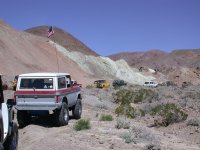
Over 22 years ago, in March 2003, Thom Singer @ntsqd led So Cal Broncos on a run through the eastern section of the Calico Mountains, including a foray up into little-visited Sunrise Canyon. During that trip Thom mentioned an old mining railroad that had existed in that area, which included a tunnel cut through a hill. We kept an eye on the hillsides but saw no sign of it on our journey that day. I've wondered about that railroad and tunnel ever since. Here's a pic that I believe is from that run. Note the white deposits on the left hand side of the canyon, I'll come back to that later:

Thom, no doubt in the ensuing years, you have since learned more about it and perhaps even visited the actual site we were looking for that day. But I've never heard you mention of it since. So if any of this is old news to you that's OK but I'd like to place the information here for future reference.
This morning I saw a post in a Facebook group (The Desert Way With Jaylyn and John - anyone interested in desert history should follow if you haven't yet) that mentioned that railroad we had briefly looked for all those years ago. Here's the text of that post along with the photo included:
That thread contributed the name of the operation as Palm Borate Company, which then led me to a PDF file that has more information on the mine, a brief history, a couple of historic photos, and maps of the claims that include a depiction of the short railroad itself. I've uploaded that PDF file to the forum, you can access it here if you'd like to take a look: https://socalbroncos.com/forum/resources/the-palm-borate-company-operations-calico.14/
Using the information in that PDF file, and referencing the satellite base map on ONX, I was able to plot what I believe was the route of the gravity railroad. I exported it as a GPX file and uploaded it here, you can get it at: https://socalbroncos.com/forum/resources/palm-borate-gravity-railroad.15/ If you are an ONX user, here is a direct link to the "route" in ONX: https://webmap.onxmaps.com/offroad/share/content?share_id=01K5S8HKA1RP21Q5XKZRABF5FS Note that this is NOT a driving route, it's just the plotted, approximate location of the historic railway. If you decide to go visit the site, observe all Tread Lightly practices.
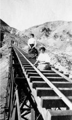
The PDF file includes this really cool picture of a couple of ladies posing on the railroad trestle. You can see where the railroad emerges from the tunnel, behind them:

So it turns out that this railroad wasn't technically in Sunrise Canyon, but in the next canyon immediately to the southwest, which is unnamed on the map. The claims associated with the mine do cross over the ridge into Sunrise Canyon. In the first photo I posted above, you can see where the borate-rich deposit touches into Surprise Canyon, where we had been back in 2003. BTW, to see the rest of my photos from that weekend, you can click here: https://dustysharp.smugmug.com/So-Cal-Broncos/2003/Calico-Mountains-March-2003 In the pics you can also see our campsite in Mule Canyon, racing across Coyote Dry Lake, visiting the Alvord Mine in the next mountain range to the east, and the red rock of Phillips Canyon.
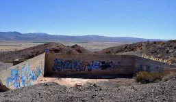
There doesn't appear to be much left of the Palm Borate operation, except for some foundations of the mill site, at the southern end of the railway, and a rectangular water reservoir at the unnamed canyon mouth, directly to the east of the railway. On the aerial photographs you can see both ends of the tunnel just to the west of the water reservoir. Immediately south of the tunnel you can see the ravine that the trestle must have spanned, just before it's southern end at the mill site.
I would like to visit this area at our next trip to the area, and close that 22-year loop. Thom, if you haven't been to it yet yourself, I'd love to go check it out with you.
PS here's the entry for this mine on MinDat, just to have all the info pertaining to this site in one place: https://www.mindat.org/loc-89211.html

Thom, no doubt in the ensuing years, you have since learned more about it and perhaps even visited the actual site we were looking for that day. But I've never heard you mention of it since. So if any of this is old news to you that's OK but I'd like to place the information here for future reference.
This morning I saw a post in a Facebook group (The Desert Way With Jaylyn and John - anyone interested in desert history should follow if you haven't yet) that mentioned that railroad we had briefly looked for all those years ago. Here's the text of that post along with the photo included:
"On the far eastern slopes of the Calico Mountains near the mouth of Sunrise Canyon, a deposit of borax shale was discovered and acquired by Borax Properties, Ltd.
A large mill was built and water supply was developed. Then the company built a small, gravity powered railroad to bring the borax shale from the deposit to the mill approximately three miles away. A hill was in the way so the company put a tunnel through the hill for the railway, then a trestle bridge got it across to the mill site.
They also built a large concrete reservoir to store water. When the Panic of 1907 struck, the price of borax dropped and the company closed without producing much borax.
You can still see the concrete foundations of the mill from I-15 if you look up at the Calico Mountains from the California Agricultural Inspection Station east of Yermo." Citation: Bill Mann's Guide to the Calicos, Vol. 3, page 97.
That rekindled my interest in the subject so I did a little more searching with the clues from that post and found more info. First, a 3D digitizing project someone had been working on back in 2015 to recreate the railroad. It includes some of his renderings as well as some historic photos he used for reference. That can be viewed here: https://carsoncarshops.com/forum/viewtopic.php?t=421That thread contributed the name of the operation as Palm Borate Company, which then led me to a PDF file that has more information on the mine, a brief history, a couple of historic photos, and maps of the claims that include a depiction of the short railroad itself. I've uploaded that PDF file to the forum, you can access it here if you'd like to take a look: https://socalbroncos.com/forum/resources/the-palm-borate-company-operations-calico.14/
Using the information in that PDF file, and referencing the satellite base map on ONX, I was able to plot what I believe was the route of the gravity railroad. I exported it as a GPX file and uploaded it here, you can get it at: https://socalbroncos.com/forum/resources/palm-borate-gravity-railroad.15/ If you are an ONX user, here is a direct link to the "route" in ONX: https://webmap.onxmaps.com/offroad/share/content?share_id=01K5S8HKA1RP21Q5XKZRABF5FS Note that this is NOT a driving route, it's just the plotted, approximate location of the historic railway. If you decide to go visit the site, observe all Tread Lightly practices.
The PDF file includes this really cool picture of a couple of ladies posing on the railroad trestle. You can see where the railroad emerges from the tunnel, behind them:

So it turns out that this railroad wasn't technically in Sunrise Canyon, but in the next canyon immediately to the southwest, which is unnamed on the map. The claims associated with the mine do cross over the ridge into Sunrise Canyon. In the first photo I posted above, you can see where the borate-rich deposit touches into Surprise Canyon, where we had been back in 2003. BTW, to see the rest of my photos from that weekend, you can click here: https://dustysharp.smugmug.com/So-Cal-Broncos/2003/Calico-Mountains-March-2003 In the pics you can also see our campsite in Mule Canyon, racing across Coyote Dry Lake, visiting the Alvord Mine in the next mountain range to the east, and the red rock of Phillips Canyon.
There doesn't appear to be much left of the Palm Borate operation, except for some foundations of the mill site, at the southern end of the railway, and a rectangular water reservoir at the unnamed canyon mouth, directly to the east of the railway. On the aerial photographs you can see both ends of the tunnel just to the west of the water reservoir. Immediately south of the tunnel you can see the ravine that the trestle must have spanned, just before it's southern end at the mill site.
I would like to visit this area at our next trip to the area, and close that 22-year loop. Thom, if you haven't been to it yet yourself, I'd love to go check it out with you.
PS here's the entry for this mine on MinDat, just to have all the info pertaining to this site in one place: https://www.mindat.org/loc-89211.html
Last edited:


